 Well, as the weather bureau predicted, the morning dawns cloudy and far from promising. Nonetheless, I believe I will stick to the
plan and head for Terlingua, Lajitas, along the Rio to Presidio, and then north to Guadalupe Mtns NP. Since Terlingua is only a few miles outside of
Study Butte I come to the turnoff for "Terlingua Ghost Town" in no time at all; in fact I almost miss it and have to make a hard right.
"Where is it?" All I see are a few building remains, some beat up lived-in houses, and just down the road a "Star Theatre" and a restaurant and some other buildings. Oh, and there is a cemetery on the left as you turn, but... Humph! I was told that it's kind of touristy and maybe there's some more, real ghost town stuff, but I'm not interested. So back on the road to Lajitas.
 About a mile from Lajitas is the Barton Warnock Environmental Education Center, run by the Texas Parks and Wildlife Department,
named after a professor at the local university in Alpine who made a career out of studying and identifying the flora of the Big Bend area. The
center, which is very new, is comprised of four wings built around an open, central garden area containing a visitors area, an exhibit area, an
auditorium, and offices. Out back is an extensive desert garden of plant species indigenous to the Chihuahuan Desert, of which Big Bend sits near it's
northern extent.
The exhibit and gardens are phenomenal! If you are in the area you must take the time to visit. It's very well done and very informative. The staff is earnest and helpful, and even cut me a break on the fees (it seems it costs a few bucks to do anything except for driving through on FM 170, the paved road that traverses the southern portion along the Rio Grande). In the auditorium, where you can see a film on the Big bend area, (which I did not take the time to see) is a collection of photographs by a local photographer that you can purchase prints from (they're ok I guess).
 After spending about an hour looking and learning I headed out once more to Lajitas a mile away. As I pull out onto the road a
coyote very nonchalantly trots across in front of me. Lajitas is being redeveloped into
a luxury desert resort, complete with golf course and time shares (you won't believe for how much), but for now is a sleepy and dusty little tourist
spot on the way to somewhere else. I continue without stopping, on to somewhere else.
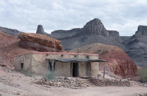
 The first stop in the park is the Contrabando Movie Set site, a small collection of "period" buildings perched on the bank of the
Rio Grande. While pulling away a trio of trucks pull up, one of which has something "Media" on its side. Could they be getting ready to make another
movie? I'll have to keep my eyes out for future releases.
The first official river access is at Grassy Banks where you can camp, picnic and/or launch craft into the river. If I had known about this place (and perhaps the others farther along the road) I might have opted to camp here for a night. It's isolated and right on the river so there's lot's of trees and brush to pretty things up, though the sites for camping are themselves are somewhat bare. Nonetheless, the temperatures are more temperate along the river and I'm sure it would be nice at the right times of the year.
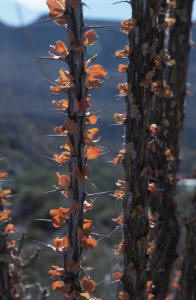 At Madera Canyon I take the high road up to a (not grassy) knoll overlooking the river. At the end of the drive I get out to take
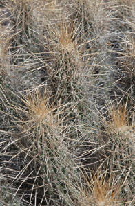
some pictures. Though still mostly cloudy it's blue sky and bright sun directly above. There is a good stand of desert vegetation here and that's what
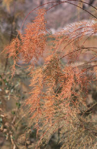
I shoot. The ocotillo here for some reason show more life than elsewhere. Normally ocotillos will be brown and gray and appear dead - though they're
not. These however, are green and fully "leaved". Interestingly, if you look at the "leaves" with the sun shining upon them they appear brown and
lifeless, but if you look at them from the other side, with the sun shining through them, they are golden and vibrant. I hope this comes out on film.
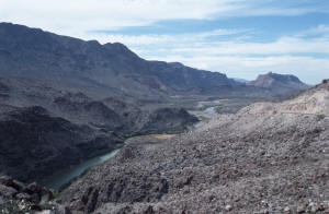
Beyond Madera Canyon the road rises to a pullout on the left. Get out and take a look at the view. It's nice. Continue on from there though and the road really rises over a little peak of jumbled boulders. Right at the top of the "summit" is a wide area on the right side. Park, get out and hike over to the left to get a great view down the river, well into or even beyond Big bend NP. I did and I'm so glad. It's not an official pullout, but it's obvious from the tracks on the path that many people have done so. Highly recommended. There is an "official" pullout just beyond the summit that gives you a nice, though not grand, view upriver. It's worth stopping for though.
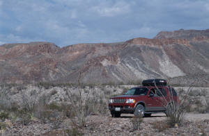
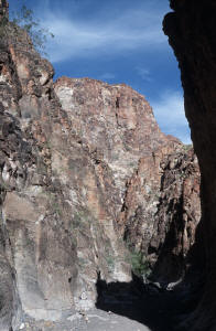
 My next stop is Closed Canyon which is why I paid $6 for a permit. It's a 0.7 mile hike into a tall, narrow canyon that leads runoff
into the Rio Grande. I can see the slot in the orange and black wall as I drive up to the parking area. Hiking along the one of the gray gravel washes
converging here at the entrance, I enter the canyon. The floor of the canyon is initially composed of the same gravel, but soon gives way to the
rounded, pale rock that soon takes over. The way is easy with only a gentle downslope.
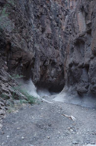 A short ways in the first of a series of constrictions and pouroffs comes into view. In the beginning they are merely a step or
few down, but as I progress I have to do some boulder hopping (down) and a little bit of scrambling. Fun! The walls of the canyon are composed of the
same pale rock as the floor, above which is a dark stone of black, brown, and orange, fading into a lighter, more orangey color at the top. The canyon
narrows the deeper into it I go. A few times I have to secure my camera gear as I carefully pick my way down, making sure that I can get back up first.
No problem!
And then, "Ooops! I guess that's it." Right ahead of me is a nearly vertical pouroff that descends about 10'. "I guess that's it. Rats!" I edge along the rocks on the right side to get a better look. "Yep. No way I can get back up that." "Wait a minute! What's that?!" I peer over the edge and lo and behold someone has conveniently left a 2x4 with a series of blocks nailed to it - a ladder! I look at it closely. "Ok. I guess I can get down and up that but there's that one block that has split in half and..." (I see the piece laying downstream.) I think about and finally decide to gingerly step my way down. Even if another block comes off I could still make it back up.
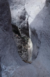 So down I go. Carefully. And soon I'm down below. I look up and think, "No way can I get back up without that ladder." The rocks
are too smooth and steep. Turning around I see that the passage is blocked, nearly, by a rockfall. I go up to inspect. There is a gap on the left side
that is big enough to squeeze through, but... I try rocking the huge boulder on top. "Well that's firm enough I guess." I look and see if I can climb
up over it - the top's only about 9' off the ground - but no way, there's nothing to grab hold of. I look at the hole again. Yeah, I'm sure I can
squeeze through, but not with my camera stuff on. So what to do with it? I stick my head trough to see if I can see what's immediately beyond, but
cannot see closer than probably 5' in front of the boulders. The gap is too high for me to just poke the camera stuff through without having to drop
it so I'm not gonna do that. Damn!
I ponder my dilemma. I want to go on, but it looks as if I'd have to leave my camera gear here, and there's probably not going to be anyone else coming in here today, but... I check the top boulder again and stick my head through again. Man! I think, I ponder, I fret. Finally, I decide that since I'm all alone and since I can't take my camera stuff with me... "Yeah, that's it! I can't just leave my camera stuff here. That's a lot of money we're talking about, and if I don't have my camera, well, what's the purpose?!" So reluctantly - very, very reluctantly - I turn around and head back up the ladder (which holds my weight without breaking again) and out to the truck. The sun, which had previously been covered by a thin layer of clouds, throws the veil off, lighting up the canyon as I trudged out as if to say, "Yeah, there you go. I'll show you the way out - you big chicken!" "Whatever!"
 Just as I'm coming up the top of the hill to my truck, 4 Border Patrol vehicles roar up into the parking area. Mine is still the
only vehicle there so... "Wow! I wonder what's going on?" Maybe they're going to set up a trap or something. A bunch of agents pile out, one of whom
greets me as I come to my truck. After that though they don't say anything to me, "Guess I'm good." After a few minutes they all take off again,
eastward, leaving one car behind. I finish putting my stuff away and get back on the road, the other way, to Presidio. "That was exciting!"
It's about 3 o'clock and has cooled off just a bit - 59° - but is still a gorgeous day. The sun has drawn it's veil across its face again, but still feels warm when outside and to the west, where I'm headed, it's looking very promising - mostly clear, blue skies. Let's get moving!
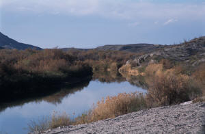
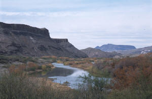
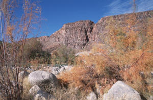
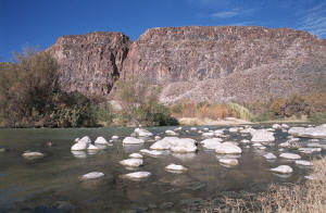
At Colorado Canyon River Access I decide to take one more up close and personal gander at the Rio. And I'm so glad I did! It's a gorgeous spot! Gentle rapids, abundant vegetation (a lot of Salt Cedars), birds flying about, with a wonderful backdrop of marvelously textured and colored rock rising precipitously from the road on the right. A very scenic little spot. I shoot almost a full roll of film just here. Let's hope some of them come out!
 Back on the road heading northwest again, the mountains and mesas start to retreat from the river and soon the Rio
is meandering across a broad plain populated with farms, first on the Mexican side only, then on both sides as the plain broadens northwards. I pass
quickly through the settlement (can't really call it a town) of Redford. Not much to it and nothing to stop for. A couple of miles beyond Redford
they're doing some road work and I am forced to wait for 25 minutes before being allowed to proceed. Bummer! But, soon enough I'm on my way again and
the road, which at this point is still unpaved - though that's being corrected - in no time at all brings me to the significantly larger border town
of Presidio. There's an official border crossing here though that's not for me this trip. I wend my way through the town without stopping, finding my
way to US 69 for the next leg of my journey northwards to Guadalupe National Park.
 It's somewhat scenic along here, as I roll up and down Rt. 67. There are some low mountains in the
distance on either side of me, and I occasionally pass by some rock outcroppings that pop up right alongside the road, two of which are denoted by
highway markers. One of them says to look for Abe Lincoln - and sure enough, there he is in profile. The other says there's an elephant over there...
And there is! I
stop at one of those historical markers and read about how all this land around here is one humongo ranch; owned and operated by the same family for
well over a hundred years. As I'm reading I have to move out of the
way of a cowboy coming through the gate - in a truck of course. I suppose they reserve the horse riding for when they're out "on the range".
Just before I hit the town of Marfa I come upon a Border Patrol checkpoint. I wait my turn and pull up for "inspection". One of the agent there, with furrowed brow, looks at me quizzically for a few moments, then asks,
"No."
"Do you know where you are?" (Still giving me the "evil" eye)
"Uh, yeah."
"Ok. You have a good day."
"Thanks!" ("What the hell was that about?!")
 The clouds that have gathered to the west over the nearby mountains finally decide to do something as I pull into and drive through
the small town of Marfa, located at the intersection of US Routes 67 & 90. I'm pelted with a smattering of large drops, then a short and quick little
shower before I pass through the "storm zone", now heading northwest on Rt. 90 towards Van Horn up on the interstate (I-10). I'm treated to a
gorgeous sunset as the sun sets behind the mountains to my left, lighting up the stormy clouds with a fiery, orange glow that so very briefly wet me with a kiss of rain . Beautiful! As the twilight deepens and the stars start coming on in the now coldly clear sky, I pass a sign for the Fort Davis
Scenic Loop, a scenic route through the nearby Davis Mountains that also passes through the town of Fort Davis, sight of the Fort Davis National
Historic Sight, a well preserved frontier fort of the old west. Maybe the next time through here.
At about 8pm I tiredly enter the town of Van Horn, where I decide to spend the night. Guadalupe Mtns. NP is now only an hour away; more than close enough for an easy drive there first thing in the morning. Besides, there's no lodging closer to the park besides White City at Carlsbad Caverns, 35 miles away on the other side. I find an ATM 'cause the cash is getting really low, and check into the local Best Western. With McDonalds for dinner I settle down for a few hours of relaxing before turning in for the night. All in all it was a very nice day. The drive along the Rio was exceptional and the little adventure in Closed Canyon was, well, adventurous. Now that I'm leaving the Big Bend area I must say that I have thoroughly enjoyed my return, after 15 years, to one of the more remote areas of the US. Because of the distance I may not return again for another 15 years (or longer), but I leave with treasured memories and, I hope, some pretty fine pictures of the magnificent landscape and scenery in the region.
